
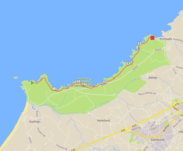
Continue east from Godrevy along dramatic clifftops, passing rocky coves and Hell’s Mouth towards Portreath.
This coast-path section leaves Godrevy Point and follows the higher cliffs towards Portreath. The route passes Mutton Cove, Navax Point, Hell’s Mouth and a succession of rugged coves. Although much of the path is clear, there are steep valleys and exposed stretches, so it is more demanding than the beach walk from Hayle. Summer bus services may provide options for the return journey.
Route directions
- From Godrevy Point, round the headland and pass Mutton Cove below. There is no beach access here, but the cove is an important seal-watching area.
- Continue east on the obvious cliff-top path. At Navax Point use the wider, more inland official route because smaller tracks can disappear into gorse and heather.
- Turn south around the headland, passing Castle Giver Cove and Fishing Cove. Both are attractive sandy coves but have no safe access from the coast path.
- Follow the broad cliff path as it runs near the B3301. Several car parks meet the route, and a limited seasonal bus can provide an escape point.
- After Fishing Cove, take the left fork to remain on the coast path; the right fork leads towards the road and car park.
- Arrive at Hell’s Mouth, one of this coast’s best-known viewpoints, with dramatic cliffs and a café near the road.
- Continue across Hudder Down. One stretch beside the road has been improved for wheelchair users, although the full route is not accessible.
- Pass the succession of small cliff-top car parks and continue when the road moves inland. Greenbank Cove lies below but has no coast-path access.
- Pass the Crane Islands and continue to Basset’s Cove. Access to the beach is difficult and is not recommended.
- Leave the rear of the car park, turn left and prepare for the steep descent into Carvannel Downs followed by a demanding climb out of the valley.
- Follow the zig-zagging path back to the cliff top and continue past Western Cove, another rocky beach without direct access.
- Portreath comes into view ahead. Follow the coast path to Battery Hill, turning left for the beach or continuing right towards the main car park and village centre.
- The route is easy to moderate overall but includes exposed cliffs and a particularly steep valley crossing near Carvannel Downs.
Highlights
- Rugged clifftop scenery
- Hell’s Mouth and hidden coves
- Finish in the coastal village of Portreath
Plan your visit
Wear proper footwear, keep back from cliff edges and check return transport before setting out.
Good to know
Prepare for the coast path
Distances alone do not show how demanding a coastal route can be. Allow for steep climbs, uneven surfaces and exposed weather. Take water, suitable footwear and layers, and check tides where the route uses beaches. Plan return transport before starting a point-to-point walk.
- Carry water and weatherproof layers
- Use an up-to-date route map
- Arrange return transport in advance
Make a day of it
Explore more around Godrevy to Portreath Walk
Pair this visit with another nearby beach, walk or attraction, then return to the comfort of your self-catering property in Hayle. The related guides below are a good place to continue planning.
Browse all things to do →